Hammas Shahid

    Senior GIS & Spatial Intelligence Engineer

    Full-Stack Architect · Enterprise Software Engineer

    I design and build enterprise geospatial and operational platforms end-to-end: spatial data models and PostGIS queries, custom map tooling, NestJS APIs, enterprise SSO, and the infrastructure they run on. Engaged directly for architecture and delivery, with clients in Australia, the UAE, the US and elsewhere.

    GIS & Spatial EngineeringEnterprise ArchitectureOperational PlatformsAI/ML Integration
    Download résumé (PDF)

    Systems I Have Built

    Two production platforms that show the range: enterprise geospatial engineering, and operational software driven by real-world sensor data.

    Flagship

    MapMyMine(opens in new tab)

    Lead Technical Consultant & Full-Stack Engineer

    Production · Australian mining organisations

    Mining rehabilitation and operational intelligence platform. I am the primary technical person responsible for the full estate: spatial model, backend, both Angular applications, the supporting Python services, enterprise authentication and infrastructure, across a multi-repository system.
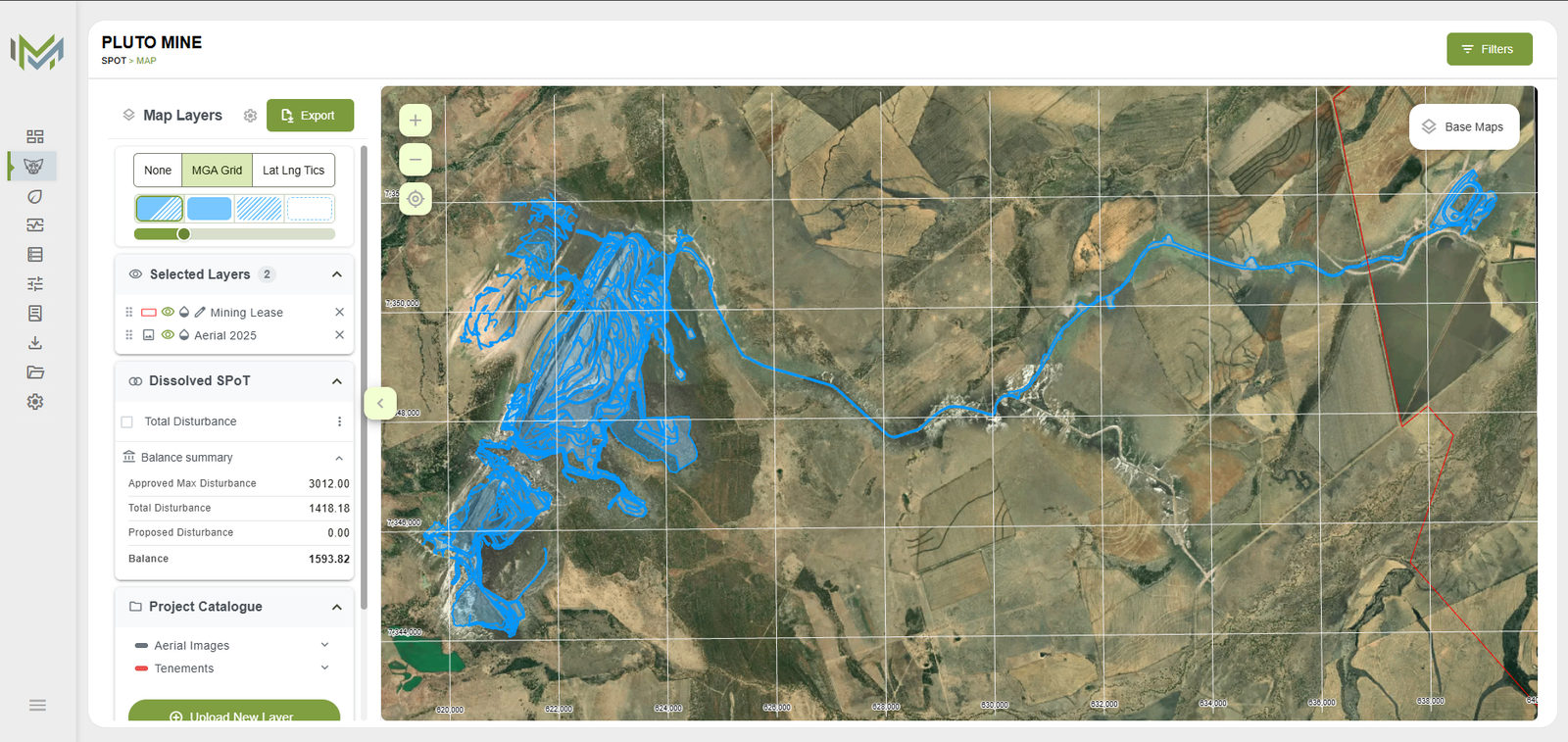
    MapMyMine SPoT map with aerial imagery and disturbance polygonsRead the case study →

    Architecture

    Angular user applicationAngular administration applicationNestJS APIPostgreSQL + PostGISPython microservicesRaster conversion pipeline

    Engineering

    Spatial engineering

    Custom OpenLayers map interaction, PostGIS-backed spatial queries, and a versioned Single Point of Truth for mine disturbance.

    Document-to-data extraction

    Turning approved regulatory documents into structured data a person reviews and accepts before the product will seed from it.

    Assistive matching

    Coded classifications are proposed against the relevant catalogue; a person locks every match before it becomes compliance truth.

    Enterprise identity

    Microsoft Entra OIDC with PKCE, domain proof, and SCIM: the organisation boundary the project-level GIS tenant sits under.

    AngularNestJSOpenLayersPostgreSQLPostGISPythonFastAPILLM integrationMicrosoft EntraMapboxGeoJSON

    Truckast(opens in new tab)

    Lead Technical Engineer

    Production · construction and ready-mix logistics

    Transport management platform for construction and ready-mix concrete logistics. Software driven by live sensor and telematics data from vehicles in the field rather than static business records.

    Engineering

    Realtime fleet operations

    Live fleet monitoring and geospatial route intelligence, with vehicle position and telematics streams rendered on operational maps.

    Sensor-driven inference

    ML-assisted workflows interpreting drum and vehicle sensor data to infer concrete delivery, pouring activity and site-level consumption events.

    Automated billing

    Billing generated from inferred operational events, turning noisy real-world sensor data into figures a business can invoice against.

    AngularMapbox GLNestJSPostgreSQLWebSocketsTelematics

    Further enterprise, TMS, ERP and AI engagements are listed under Professional Experience.

    Professional Experience

    Current Role

    Senior GIS & Enterprise Systems Consultant

    Independent Consultant

    08/2025 - present

    Lahore, Pakistan

    • Independent technical consultant to international clients, primarily in Australia, on geospatial and enterprise platforms
    • Engaged for architecture and delivery rather than task execution: scoping the problem, designing the system, and building it

    Client engagement

    MapMyMine(opens in new tab)

    Lead Technical Consultant & Full-Stack Engineer

    08/2025 - present

    Australia (remote)

    • Primary technical person responsible for the full platform: PostGIS spatial model, NestJS API, both Angular applications, the FastAPI ML service and cloud infrastructure
    • Working directly with the product owner on roadmap and architecture decisions as an independent consultant, not through an agency or delivery team
    • Ongoing work across GIS functionality, enterprise authentication, security, performance and DevOps on a live system with commercial users

    Read the MapMyMine case study →

    Previous Full-Time Positions

    Lead Full-Stack Engineer

    OneClout

    09/2024 - 08/2025

    Lahore

    • Lead technical engineer on Truckast, a concrete industry TMS integrating Angular with Mapbox GL for real-time fleet monitoring and geospatial route intelligence
    • Built ML-assisted sensor analytics workflows on Truckast for automated concrete delivery, pouring activity detection, and billing generation
    • Enhanced Dialog stakeholder management platform with advanced data visualisation and performance optimisations

    Full-Stack Architect

    Innovinci Tech

    05/2024 - 09/2024

    Lahore

    • Led architecture and development of custom CRM for Bitcoin ATM deployment in the US market
    • Designed secure backend systems using NestJS, PostgreSQL, and TypeORM with role-based access control
    • Built Angular frontend with real-time notifications via Firebase Firestore
    • Implemented Firebase Authentication and enterprise-grade security patterns

    Lead Full-Stack Engineer

    Coders Base Solutions

    12/2021 - 04/2024

    Lahore

    • Architected and deployed SaaS-based Transportation Management System (TMS) for logistics operations
    • Built responsive Angular frontend with geospatial route intelligence and real-time operations monitoring
    • Designed scalable NestJS backend services with PostgreSQL and microservices architecture
    • Integrated real-time truck tracking APIs, telematics, and live fleet monitoring dashboards
    • Delivered shipment tracking dashboards, admin features, and automated operational workflows

    Full-Stack Developer

    Freelance / Self-employed

    2020 - 2021

    Lahore

    • Built web applications and REST APIs for early clients using Angular, Node.js and PostgreSQL, delivering both frontend and backend before moving into full-time roles

    Selected Contract Engagements

    Kollab.AI, Lead Backend Developer & Architect(opens in new tab)

    Architected an AI-powered productivity platform with OpenAI integration, NLP-driven workflows, multi-tenant organisation management, and real-time conversational interfaces.

    Dialog(opens in new tab)

    Contributed to an enterprise stakeholder management platform for public-space and infrastructure projects, working on data visualisation and performance across stakeholder databases, engagement tracking and strategic environment management.

    MyTaxDesk, Lead Backend Developer & Architect

    Developed enterprise CRM for UAE tax consultancy with compliance operations, real-time client engagement, case tracking, and workflow automation.

    Transportation Management System (TMS), Lead Full-Stack Engineer

    SaaS logistics platform with real-time fleet tracking, geospatial route intelligence, telematics integration, and scalable NestJS microservices architecture.

    EMSS, Backend Developer

    Delivered backend architecture for TMS and CRM serving logistics clients in the UAE with real-time operational tracking.

    Adaa Employment LLC, Full-Stack Developer & Architect

    Architected and built a workforce management platform covering the full employee lifecycle, from hiring and onboarding through performance tracking and offboarding, including payroll processing, gratuity calculations and role-based access control.

    Enterprise ERP & Web Applications

    Delivered enterprise-grade platforms across mining, logistics, taxation, and business automation with end-to-end architecture ownership.

    Where I Work

    The systems I take on tend to be difficult because of the domain and the architecture, not because of the volume of code.

    Mining, Resources & GIS

    • Spatial data modelling, PostGIS query design, and coordinate system and transformation handling
    • Custom web mapping interaction built on OpenLayers where off-the-shelf GIS tooling falls short
    • Raster and vector processing, GIS import and export, and GeoJSON spatial workflows
    • Mining rehabilitation and environmental compliance processes

    Operational & Realtime Systems

    • Platforms driven by live telematics, GPS and sensor streams rather than static business records
    • WebSocket realtime data flow and live operational dashboards
    • Turning noisy real-world signals into auditable, billable business events
    • Transport management, fleet tracking and scheduling systems

    Enterprise Platforms

    • Multi-tenant organisation and project architecture
    • Enterprise SSO via Microsoft Entra and OIDC, with role-based access control
    • ERP, workforce management, and taxation and compliance operations
    • Reporting and analytics built for operational decision-making

    AI & ML Integration

    • Multimodal document pipelines that turn regulatory PDFs into validated, typed data
    • Models chosen per job against cost and capability, not one model for everything
    • Deterministic verification around every model output, with graceful degradation when a provider fails
    • Assist-only by design: models propose, code verifies, a person accepts before anything becomes system truth

    Scope of ownership

    A single spatial feature usually touches every one of these layers. I work across all of them rather than handing the problem across team boundaries, which is also what makes me useful on large existing codebases, where understanding the current architecture and making safe changes is most of the work.

    User workflowSpatial modelDatabase designPostGIS queriesMap interactionBackend APIsSpatial calculationsImport / exportAuth & permissionsInfrastructurePerformanceTesting & deployment

    Stack

    The tools I work in daily and would be comfortable being questioned on in depth.

    GIS & Spatial

    OpenLayersPostGISGeoJSONMapbox GLRaster & vector processingCoordinate systems

    Application

    AngularTypeScriptNestJSNode.jsREST APIsWebSockets

    Data & ML

    PostgreSQLTypeORMPythonFastAPIOpenAI / GPT-4oSentence transformersDocument extraction pipelines

    Platform & Security

    Microsoft Entra / OIDCRBACDockerLinuxNginxCI/CD

    Work with me

    Consulting engagements on geospatial, operational and enterprise platforms.

    5k10k15kNAustraliaUAEUSLahore

    Where the work is

    Based in
    Lahore, Pakistan 31.5°N, 74.4°E
    Delivered in
    Mining compliance in Australia, enterprise systems in the UAE, fleet and logistics platforms in the US
    Offset
    UTC+5, no daylight saving

    Azimuthal equidistant projection centred on Lahore, rings every 5,000 km. Markers are regional, not client addresses.

    Contact Information

    Phone

    +92-313-7756927

    Location

    Lahore, Pakistan

    Engagement

    Working as
    Independent consultant, contracting directly
    Engagements
    Long-running technical ownership, architecture and end-to-end delivery
    Time zone
    UTC+5, no daylight saving
    Clients
    Australia, UAE, US and elsewhere; remote

    Connect

    © 2026 Hammas Shahid · hammasshahid.com